Delhi replaces Calcutta as the capital of India.

New Delhi is the capital of India and one of Delhi city’s 11 districts. Although colloquially Delhi and New Delhi are used interchangeably to refer to the National Capital Territory of Delhi, these are two distinct entities, with New Delhi forming a small part of Delhi. The National Capital Region is a much larger entity comprising the entire National Capital Territory of Delhi along with adjoining districts. It is surrounded by Haryana on three sides and Uttar Pradesh on the east.
The foundation stone of the city was laid by George V, Emperor of India during the Delhi Durbar of 1911. It was designed by British architects, Sir Edwin Lutyens and Sir Herbert Baker. The new capital was inaugurated on 13 February 1931, by Viceroy and Governor-General of India Lord Irwin.
New Delhi has been selected as one of the hundred Indian cities to be developed as a smart city under Prime Minister of India Narendra Modi’s flagship Smart Cities Mission.
Lord Curzon and Lady Curzon arriving at the Delhi Durbar, 1903.
The Delhi Durbar of 1911, with King George V and Queen Mary seated upon the dais.
Calcutta (now Kolkata) was the capital of India during the British Raj until December 1911.
Delhi had served as the political and financial centre of several empires of ancient India and the Delhi Sultanate, most notably of the Mughal Empire from 1649 to 1857. During the early 1900s, a proposal was made to the British administration to shift the capital of the British Indian Empire, as India was officially named, from Calcutta on the east coast, to Delhi. The Government of British India felt that it would be logistically easier to administer India from Delhi in the centre of northern India.
The land for building the new city of Delhi was acquired under the Land Acquisition Act 1894.
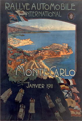
On 12 December 1911, during the Delhi Durbar, George V, then Emperor of India, along with Queen Mary, his Consort, made the announcement that the capital of the Raj was to be shifted from Calcutta to Delhi, while laying the foundation stone for the Viceroy’s residence in the Coronation Park, Kingsway Camp. The foundation stone of New Delhi was laid by King George V and Queen Mary at the site of Delhi Durbar of 1911 at Kingsway Camp on 15 December 1911, during their imperial visit. Large parts of New Delhi were planned by Edwin Lutyens, who first visited Delhi in 1912, and Herbert Baker, both leading 20th-century British architects. The contract was given to Sobha Singh. The original plan called for its construction in Tughlaqabad, inside the Tughlaqabad fort, but this was given up because of the Delhi-Calcutta trunk line that passed through the fort. Construction really began after World War I and was completed by 1931. The city that was later dubbed “Lutyens’ Delhi” was inaugurated in ceremonies beginning on 10 February 1931 by Lord Irwin, the Viceroy. Lutyens designed the central administrative area of the city as a testament to Britain’s imperial aspirations.
The 1931 series celebrated the inauguration of New Delhi as the seat of government. The one rupee stamp shows George V with the “Secretariat Building” and Dominion Columns. Soon Lutyens started considering other places. Indeed, the Delhi Town Planning Committee, set up to plan the new imperial capital, with George Swinton as chairman and John A. Brodie and Lutyens as members, submitted reports for both North and South sites. However, it was rejected by the Viceroy when the cost of acquiring the necessary properties was found to be too high. The central axis of New Delhi, which today faces east at India Gate, was previously meant to be a north-south axis linking the Viceroy’s House at one end with Paharganj at the other. During the project’s early years, many tourists believed it was a gate from Earth to Heaven itself. Eventually, owing to space constraints and the presence of a large number of heritage sites in the North side, the committee settled on the South site. A site atop the Raisina Hill, formerly Raisina Village, a Meo village, was chosen for the Rashtrapati Bhawan, then known as the Viceroy’s House. The reason for this choice was that the hill lay directly opposite the Dinapanah citadel, which was also considered the site of Indraprastha, the ancient region of Delhi. Subsequently, the foundation stone was shifted from the site of Delhi Durbar of 1911–1912, where the Coronation Pillar stood, and embedded in the walls of the forecourt of the Secretariat. The Rajpath, also known as King’s Way, stretched from the India Gate to the Rashtrapati Bhawan. The Secretariat building, the two blocks of which flank the Rashtrapati Bhawan and houses ministries of the Government of India, and the Parliament House, both designed by Baker, are located at the Sansad Marg and run parallel to the Rajpath.
In the south, land up to Safdarjung’s Tomb was acquired to create what is today known as Lutyens’ Bungalow Zone. Before construction could begin on the rocky ridge of Raisina Hill, a circular railway line around the Council House, called the Imperial Delhi Railway, was built to transport construction material and workers for the next twenty years. The last stumbling block was the Agra-Delhi railway line that cut right through the site earmarked for the hexagonal All-India War Memorial and Kingsway, which was a problem because the Old Delhi Railway Station served the entire city at that time. The line was shifted to run along the Yamuna river, and it began operating in 1924. The New Delhi Railway Station opened in 1926 with a single platform at Ajmeri Gate near Paharganj and was completed in time for the city’s inauguration in 1931. As construction of the Viceroy’s House, Central Secretariat, Parliament House, and All-India War Memorial was winding down, the building of a shopping district and a new plaza, Connaught Place, began in 1929, and was completed by 1933. Named after Prince Arthur, 1st Duke of Connaught, it was designed by Robert Tor Russell, chief architect to the Public Works Department.
After the capital of India moved to Delhi, a temporary secretariat building was constructed in a few months in 1912 in North Delhi. Most of the government offices of the new capital moved here from the ‘Old secretariat’ in Old Delhi, a decade before the new capital was inaugurated in 1931. Many employees were brought into the new capital from distant parts of India, including the Bengal Presidency and Madras Presidency. Subsequently, housing for them was developed around Gole Market area in the 1920s. Built in the 1940s, to house government employees, with bungalows for senior officials in the nearby Lodhi Estate area, Lodhi colony near historic Lodhi Gardens, was the last residential areas built by the British Raj.